Stand Up Paddleboarding the Zion Narrows
A Paddler's Guide and Trip Report
By Garrett Bennett - Hala Ambassador

In 1872 when John Wesley Powell, one of the greatest explorers of the Western rivers arrived in what is now Zion National Park for the first time he said, “the Indians call the canyon through which it runs ‘Mu-koon’-tu-weap’ or Straight Canyon. Entering this, often the water fills the entire channel, and although we travel many miles, we find no flood plain, talus, or broken piles of rock at the foot of the cliff. The walls have smooth plain faces and are everywhere very regular and vertical for a thousand feet or more.” It is this spirit of exploration that drives me today over 150 years later, a quest into an unknown landscape, a journey to understand both the natural environment and in the end, myself. This is what I have been chasing on the creeks and rivers for almost ten years with my Stand Up Paddleboard as the ideal platform to provide access into some of what would be the most non accessible wilds otherwise. You may ask yourself many questions, such as “where would I begin to prepare for a journey such as this, what are the hazards and concerns, how can it be done safely, and what sort of logistics and difficulties are associated with such a remote trip in a canyon river in which the only way to escape once entering is down and out?” Never fear, we will take you through all aspects of this trip, from pre-planning, permits and desired conditions, getting there, gearing up, the related hazards, as well as a breakdown of the run itself.

![]() Permits and Conditions
Permits and Conditions
Timing this trip can be difficult. Some years, plenty of runnable windows exist, in other years, none at all. Local outfitters suggest that there is no way to know the setup until typically a month prior; even then, things can quickly change. Timing this run properly is also important for safety as levels can quickly rise. This makes the descent a challenge. To get a permit, you will need to show up the day prior at the Zion Backcountry desk. Same-day permits are not issued. The requirements are that the levels on the USGS gage “N. Fork Virgin River near Springdale, Utah” must remain over 150cfs for 24 straight hours. Levels above 500cfs should be avoided for your enjoyment and safety. NPS requirements also state that “watercraft must be designed for whitewater use,” and that the maximum group size is six people. The N. Fork of the Virgin River watershed comprises 400 square miles of terrain, mostly North of the Narrows, making the typical season to attempt this between March and June as the snows melt off. Once NPS rangers decide the water is getting too low, or at their discretion, for any reason, permits may no longer be issued for the remainder of that season.

Trip Duration
This trip can be done as a single long day or broken into a two-day trip; both will have advantages and disadvantages. If looking to do it in one day, a huge benefit is that you are travelling light, but some gear will still need to be brought along in case of emergency. That said, being able to leave behind everything needed to camp overnight certainly provides an advantage. If doing the single-day trip, the hike or float through the initial 3 miles to Bulloch’s Cabin ideally begins before the sun has risen. This can turn into a long day and if anything goes wrong, result in a forced bivy overnight. On the other hand, if doing a two-day trip, the issue becomes managing all the equipment, specifically through the first 7 miles of the N. Fork of the Virgin River, where the water is low prior to the confluence with Deep Creek.
Getting There
Two options exist to get to the Chamberlain Ranch Trailhead, which is located on the East Side of the Park. You can drive yourself to the trailhead or hire a NPS permitted outfitter to provide a shuttle service. With standard road conditions, you can expect the trip from Springdale to take about 1.5 to 2 hours. The road can be impassible many times due to poor conditions, some seasons, the road has not opened until well into June or later. The good news is that it is highly exposed to wind and sun allowing it to dry after recent precipitation in as little as two to four days. The trip will finish within Zion National Park at the Temple of Sinawava bus stop. As of 2024, these buses stop running at 7:15 pm from March to May 20, and at 8:15 pm from May 21st to September 17th. The alternative option is when getting your permit to accept a parking pass, allowing you to drive directly to this endpoint at Sinawava and drop a car at the takeout there.

The Hazards
This trip is Class 3, with Class 5 consequences. It is important to take it seriously as rescues could one day result in a loss of access. Any mistakes in this environment can result in a bad situation as the only way out to safety is to not lose your SUP and make to the end. The first hazard is water level, if low and less than 200cfs a lot of time may be needed to get through this trip before dark. If too high it is flat out dangerous. Conditions can shift drastically during the course of a day as the night cools down, slowing the snowmelt, which then begins melting again resulting in pulses of water. These pulses can increase flow rate, and it’s important that you study the USGS gage beforehand to feel out to what extent this is happening. Also, do not attempt this trip during precipitation due to flash floods. Hypothermia is another huge concern as the canyon gets little sunlight in places and is deep. As per drinking water, as of Spring 2024 cyanobacteria were found in the river and is not suggested by the NPS for use, filter your water from a spring along the way, Big Spring being a great place. The next major risks are pinning, losing your SUP or getting injured. You may not get rescue for some time, if you lose your SUP or pin and cannot get it back, you will have no way to safely get through the trip. Be totally self-sufficient as this is a serious wilderness journey. Carry medical kits, pin kits, and be ready to assist your fellow riders in SUP recovery if needed. Logjams, logs, rocks and debris are always shifting and a big hazard, scout when needed and keep an eye for eddies to know you have a place to get off to the side. Two large sieves are located along the trip as of 2024, they are obvious if paying attention. On this trip, awareness is a must. Lastly, and related to all of the above, is time. This river has many variables and seems to have a way of taking more time than you will expect. This can create a situation where it is becoming dark before you get to a safe location, leading to other bad decisions that combine together, creating an epic problem. This occurred to a group of four kayakers behind us. Three of the four indeed would become trapped overnight, unprepared.
Gearing Up
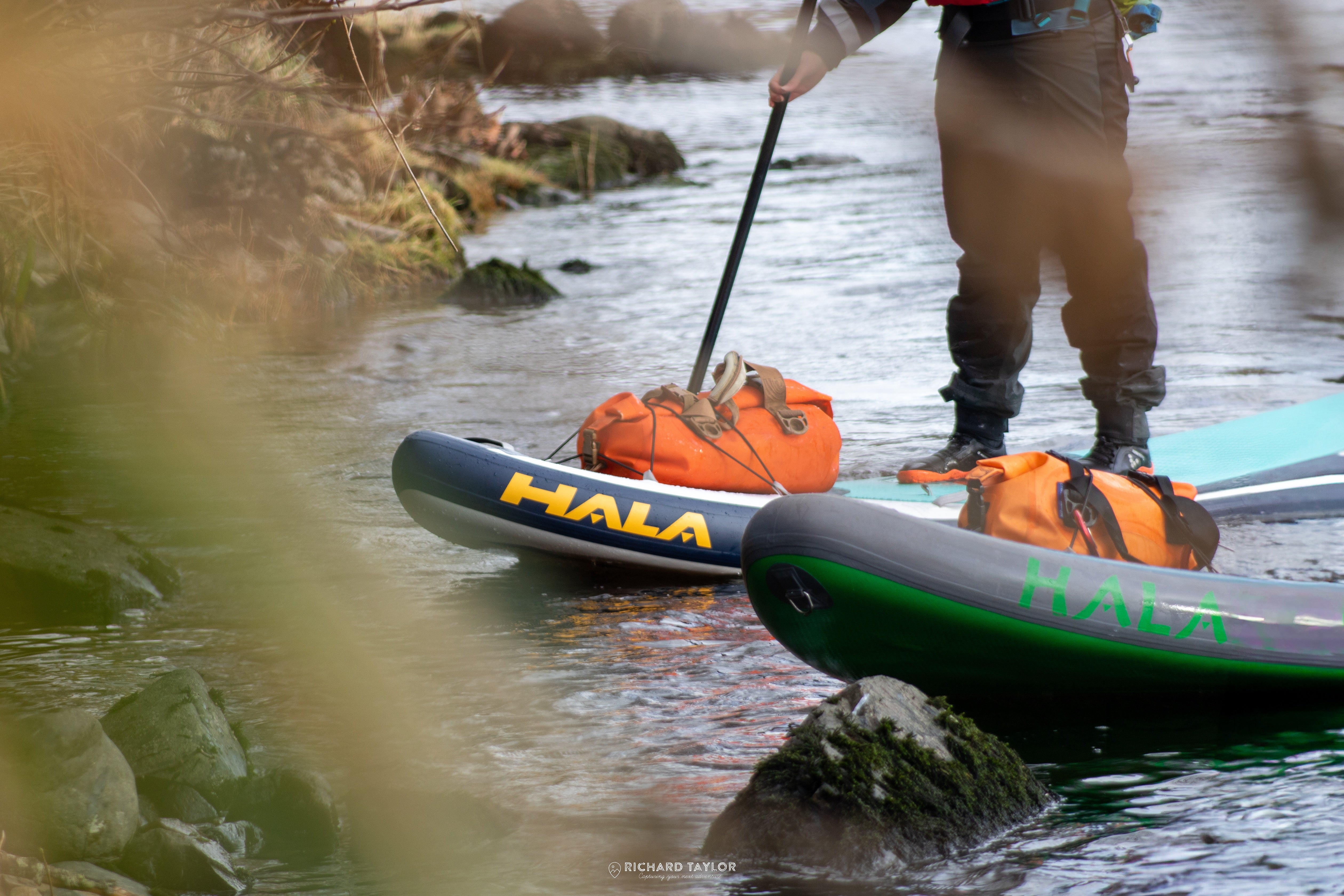
The following is a list of suggested items for a single-day trip. If doing an overnight trip, all additional items needed such as a stove, sleeping bag etc. must be added. Be sure all is lightweight and easy to pack. At minimum: Whitewater SUP, repair kit, lightweight pump, extra paddle, dry suit/wetsuit, proper footwear, rescue pfd, gloves, helmet, extra warm clothing in drybag, pin kit, small collapsible saw, medical kit, headlamp, lighters, reststop bags for waste, a rescue beacon (we did get service in sections of the trip), water filtration, drybags, and food. If expecting low levels, trekking poles may be a good option for the hike in.

The Trip: 16 total miles
Section One
Chamberlain Ranch to Deep Creek Confluence - 7 Miles
As my friend and I arrived at Chamberlain Ranch in the early morning, we decided at the current levels to go directly to Deep Creek on the river. Another group of four kayakers also arrived; this would be the only other group going through on this day. All were local and friendly people. None of any of us had yet completed this trip. The other group agreed that it made sense to run the river directly from the trailhead. In the end this cost us all a lot of extra time and made for an exceptionally long day due to too much portaging. Looking back the best option was to carry our gear the first three or four miles as the hiking is easy to Bullock’s Cabin. If doing this, from the trailhead follow the small dirt road and cross the river (it is more stream than river at this point) for about three miles. You are passing through the Chamberlain Ranch so stay on road/trail. Once beyond the cabin the gorge will begin to develop. As long as the water level remains too low to go from hiking in the river to being able to SUP it continue to move downcanyon on foot. Once the depth appears suitable for your low-flow paddling abilities, inflate and rig at that time. At levels below 200cfs, you will most likely end up hiking the entire seven miles to Deep Creek, where plenty of water will then flow in. Expect up to five hours or more to do this. If 250cfs or higher, and paddling this bit, a few rapids will exist. Just above Deep Creek will be the North Fork Waterfall, a drop of about 12 feet. Bypass this waterfall on river left up through a slot in the rock, and back down into the river. Shortly after you will arrive at Deep Creek, and if spending the night this area would be a good place to grab a camp. If continuing on for the day, check your time and expect another 3 to 6 hours, depending on the conditions as well as the variable of how quickly you can travel.
Section Two
Deep Creek to Temple of Sinawava
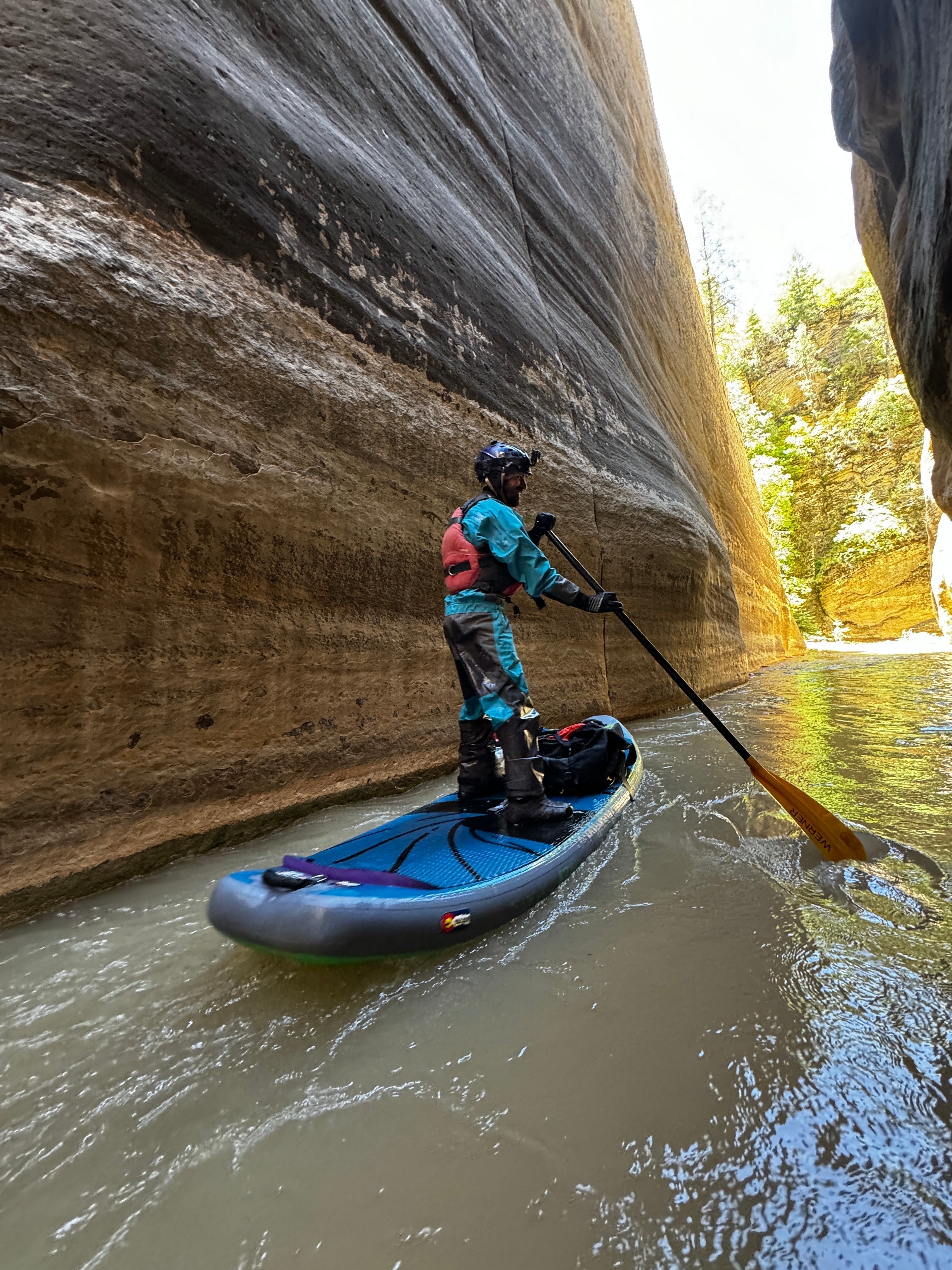
Below Deep Creek, the action will quickly begin as you speed through a wonderland of towering cliffs, flowing natural springs, green trees and ferns, and an echo chamber of amplified river sound as you're passing between 1000-foot-plus vertical walls. Over the next four river miles to just below the final camp (camp 12) and Big Spring, expect solid class 2 and 3 paddling with many rapids terminating into the vertical cliff walls, creating reactive currents and limiting the ability to brace with your paddle on one side. Small brown signs numbered from 2 to 12, marking the campsites typically used by backpackers, will be along this section. The NPS will likely update you upon getting a permit where the bad areas currently are as per logjams and these sites are a great reference. About halfway through this section is a dangerous yet possibly runnable jumble of blocks. Be careful and set safety if attempting this, although given the environment, we felt it was best portaged. Continuing on as you pass campsite 11, be on the lookout for camp 12. It is important that you eddy out on river left at this site as directly below it is a unrunnable pile of blocks forming bad sieves. If you eddy out on river right at higher levels, getting back across to river left from that gravel bar could be tough. Hike up and through campsite 12, putting in below the mandatory portage. Immediately after this Big Spring comes up on river right, this is an excellent place to fill water and a fern-covered oasis. The section below Big Spring will be one of the best bits of the run as you enter “Wall Street” a section of the canyon created by 18 million years of erosion cutting vertical walls up to 1500 feet deep. At about river mile 13 “Wall Street” will end and soon you will pass Orderville Canyon on river left. From here to the paved riverwalk, the paddling complexity starts to ease into class one and two sections. Once you see the paved trail on river left, you have the option to pull off if needed and hike the remaining short bit to the Sinawava parking lot. If continuing downriver, you will soon reach a few more complex rapids created by large boulders with small drops. Be cautious here as they are serious. These are best scouted and portaged if needed using the trails on river left. Below this is a straightforward mile or so before seeing the parking lot itself on the left. A small sand beach with a short trail will become obvious. This is the takeout.

Stand Up Paddleboarding the Zion Narrows is to travel back in time through a geologic wonderland, the energy of it was breathtaking. The vibrations of the river echoing inside of the canyon walls, the natural springs, lush vegetation, and the beautiful paddling provided us with one of the most special moments in our lives. The first thing said to me as we arrived at the takeout by my friend Kevin was “That was the best river run I have ever done.” As the sun set and we were driving out in a blissful daze processing it all we were quickly reminded of the respect that is needed to explore such places when the kayak of a team member from the group behind us was on the side of the road. Of the four people in that crew, only he had made it out. Exhausted and on adrenaline fatigue he passed by the takeout within 100 feet having no idea and continued on for two more miles. We picked him up, and drove him back to Sinawava in hopes his friends would be there, but they were not. We notified NPS law enforcement who asked us if we thought they would get out that night. As I said “I do not think so” heaviness came over me, considering what they could be going through as pitch darkness folded over us. It was a reminder of the flip side to the coin of true exploration and adventure, the reality that these are serious places and that despite their absolute beauty need always to be respected. The following day we received word that one of the three had safely made it out that morning, and that the other two ended up stuck in the Narrows after a foot entrapment resulting in two lost kayaks and a broken ankle. Zion SAR would rescue them using a helicopter and longline later that day, a testament to the immensity of all that is Zion. Peace came over us now knowing that they were well. All of that energy, visual, psychological and emotional was with us as we drove back to the South, up and across the Kaibab Plateau. As I curved East heading towards Jacobs Lake, I saw in the mirror the multicolored sandstone and beauty of Zion disappearing and as it faded away I knew the gift that nature had just provided us. I was filled with appreciation for this natural world. My heart was full.

Leave a comment
This site is protected by hCaptcha and the hCaptcha Privacy Policy and Terms of Service apply.